Remove Hurricane Remove Map Remove Track
article thumbnail

Activating Damage Assessment System for Hurricane Ian

VisionLink

Currently focused on Flo rida’s Gulf Coast, Hurricane Ian’s particular track, combined with the shape of the bay, means that significant storm surges may inundate the Tampa Bay region. Because of the slow-moving storm, other more distant areas may also receive large amounts of rain or coastal surge.

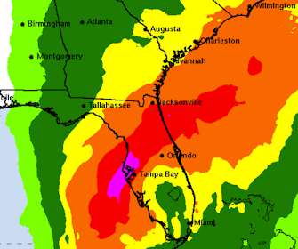
Hurricane 246
article thumbnail

Geo-Tagged Map Shows Impact of Hurricane Joaquin in Real Time

VisionLink

Map illustrates damage reports as hurricane hits North Carolina. 5, 2015— VisionLink , a community inspired software and consulting company, has developed a free, shareable, real-time, geo-tagged map depicting actual damage reports produced by Hurricane Joaquin. BOULDER, Colo. —

Hurricane 100
professionals

Sign Up for our Newsletter

This site is protected by reCAPTCHA and the Google Privacy Policy and Terms of Service apply.

article thumbnail

Visionlink Supports Dorian Response

VisionLink

Visionlink systems are fully engaged with Hurricane Dorian response. The National Shelter System is being used to help manage dozens of shelters in Florida--and states north, as Dorian continues along its predicted track.

Support 100
article thumbnail

Mapping for Impact: This Week's Free TechSoup Webinar

Tech Soup

Perhaps some organizations make it look simple, but behind the scenes there may be some sophisticated Esri tools that map disease outbreaks and aid distribution. They're also currently involved in a very recent disaster relief effort from Hurricane Isaac. In our webinar this Thursday, September 13, at 11 a.m.

Map 55
article thumbnail

Tips to Maintain Momentum for Your In-Person Fundraising Events Amidst COVID-19

Connection Cafe

Early in my career, I worked on the Race for the Cure in Houston when a hurricane swept through 10 days before our event. Our mission to end cancer is equally important as the hurricane relief efforts. Our mission to end cancer is equally important as the hurricane relief efforts. Looking for an alternative to a cycling event?

article thumbnail

Technology's Impact on Disaster Relief

Tech Soup

Relief organizations and first-responders are working tirelessly to provide aid to those affected by Hurricane Sandy. The staff at TechSoup Global is keeping all those affected by the devastating hurricane in our thoughts as we work to support recovery efforts. Google's Hurricane Sandy map currently shows areas with power outages.

article thumbnail

Saving the World One Tech Innovation at a Time

Tech Soup

Imagine a hurricane bearing down on an isolated village. Relatively new technologies in the report include GPS tracking, mapping, crowdsourcing, cloud technology, portable networks, and drone technology. Before the hurricane hit, residents could receive location-targeted SMS messages directing them to evacuate.