This site uses cookies to improve your experience. To help us insure we adhere to various privacy regulations, please select your country/region of residence. If you do not select a country, we will assume you are from the United States. Select your Cookie Settings or view our Privacy Policy and Terms of Use.
Cookie Settings
Cookies and similar technologies are used on this website for proper function of the website, for tracking performance analytics and for marketing purposes. We and some of our third-party providers may use cookie data for various purposes. Please review the cookie settings below and choose your preference.
Used for the proper function of the website
Used for monitoring website traffic and interactions
Cookie Settings
Cookies and similar technologies are used on this website for proper function of the website, for tracking performance analytics and for marketing purposes. We and some of our third-party providers may use cookie data for various purposes. Please review the cookie settings below and choose your preference.
Strictly Necessary: Used for the proper function of the website
Performance/Analytics: Used for monitoring website traffic and interactions
Our thoughts and prayers go out to the dozens who lost their lives, their families, and to the many more recovering from what appears to be the 5th most serious hurricane on record. It is creat ed using a simple mapping tool in CommunityOS, thus there is no data to transfer or convert and at no extra cost.
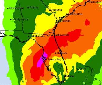
Currently focused on Flo rida’s Gulf Coast, Hurricane Ian’s particular track, combined with the shape of the bay, means that significant storm surges may inundate the Tampa Bay region. Because of the slow-moving storm, other more distant areas may also receive large amounts of rain or coastal surge.
Geospatial mapping is an increasingly hot topic in large-scale natural disasters, including Hurricane Sandy and the Oklahoma Tornadoes. As technology continues to advance, data mapping is moving from being a powerful tool for specific cases to being a new norm in all disaster relief. Sincerely, VisionLink'
Map illustrates damage reports as hurricane hits North Carolina. 5, 2015— VisionLink , a community inspired software and consulting company, has developed a free, shareable, real-time, geo-tagged map depicting actual damage reports produced by Hurricane Joaquin. BOULDER, Colo. —
Because each layer in the planet's atmosphere hosts unique winds carrying different elements, the researchers could map an unprecedented 3D structure of an exoplanet's atmosphere. Even the strongest hurricanes in the Solar System seem calm in comparison," Seidel said. Kornmesser That sodium jet stream is particularly potent.
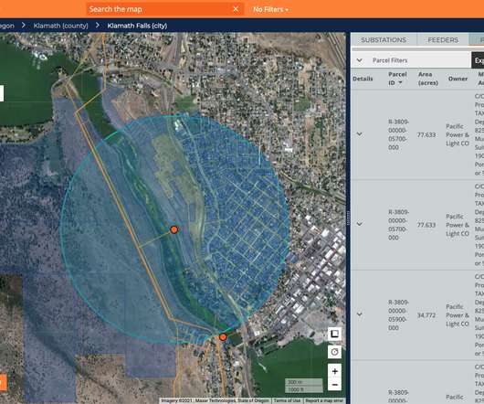
In particular, the new multiple marks layers feature lets you add an unlimited number of layers to the map. This means you can visualize multiple sets of location data in context of one another, and there’s no need for external tools to build custom background maps. . Drag and drop map layers—yes, it’s just that easy.
Big Sunday , a service organization based in Los Angeles, provided a list of resources during the wildfires in 2025, including evacuation sites, air quality maps, and insurance tips. These are all fair questions that fundraisers should be empowered to answer.
Several of the NNTSP partners are combining efforts for a response to Hurricane Sandy. You can help by making offers of technology devices and other support via Microsoft's ReadyReach Hurricane Sandy Portal , or at: National Donations Management Network Pennsylvania. What Can You Do to Help? Aidmatrix New York City.
Many do not have specialized skills but do have a passion to help those left hungry or stranded by a flood, hurricane, or fire. Prep a “Go Kit” As volunteers arrive for their assignments, provide them with necessary supplies, such as volunteer ID, maps, special equipment, and contact information for volunteer coordinators.
Perhaps some organizations make it look simple, but behind the scenes there may be some sophisticated Esri tools that map disease outbreaks and aid distribution. They're also currently involved in a very recent disaster relief effort from Hurricane Isaac. In our webinar this Thursday, September 13, at 11 a.m.
Relief organizations and first-responders are working tirelessly to provide aid to those affected by Hurricane Sandy. The staff at TechSoup Global is keeping all those affected by the devastating hurricane in our thoughts as we work to support recovery efforts. Google's Hurricane Sandy map currently shows areas with power outages.
She did a lot of work on the hurricane aftermath (she's an expert on hazardous waste, and a gazillion other things). Any IT setup has to be distributed as we saw so many single point data sources taken out by Hurricane Katrina, with no alternate location for getting same data stream. I thought her comments would be worth posting.
Preparing for Hurricane Irene? The application is free; it maps information about open shelters, and provides information about location, capacity and more very useful to those near the disaster area. Be sure to keep up to date with Disaster Shelter information from the American Red Cross.
You can use this data feed to drive information in your resource system, to display on maps and more. Here''s to only moderate damage from Hurricane Irene. You can have an account on the National Shelter System, or have access to the XML open shelters data feed. Douglas Zimmerman President & CEO VisionLink, Inc.'
In particular, the new multiple marks layers feature lets you add an unlimited number of layers to the map. This means you can visualize multiple sets of location data in context of one another, and there’s no need for external tools to build custom background maps. . Drag and drop map layers—yes, it’s just that easy.
Another direct content example is that of the number of websites that emerged post-Hurricane Katrina. The first example is Ushahidi – originally designed as a tool for mapping reports of violence in Kenya after the post-election unrest in 2008. I will explain the use of mapping, fundraising, and crowdsourcing.
Hurricane Katrina had just happened, and many experts viewed it primarily as a failure of the government to take care of its weakest citizens in the face of a natural disaster, not as climate change’s early shot. FEMA maps are increasingly becoming obsolete; 100-year floods are happening every few years. The list goes on.
Visionlink systems are fully engaged with Hurricane Dorian response. If you would like to check on currently open shelters you can visit the public view of the Shelter System at the Red Cross: Map of Open Shelters.
As COVID accelerates innovative uses of AI in many areas, we are also seeing more development of AI-powered data mapping tools for philanthropic advising and to support donor investment decisions. The post Philgorithms: Two Examples of Data Mapping to Guide Donor Decisions first appeared on Beth’s Blog. NAVi seeks to fill these gaps.
NYC leverages social media to map evacuation info for Hurricane Sandy | SmartBlogs SmartBlogs : The City of New York utilized its Open Data platform to help residents deal with the effects of Hurricane Sandy.
(Android, iOS, Windows Phone) connects you with friends and family during a large-scale disaster such as an earthquake or a hurricane. The Esri ArcGIS app (Windows 8) is useful for organizations that wish to build their own relief-related maps. The app lets you preview different data skews and features from Esri's mapping software.
There's also a Google Crisis Map. published an interactive map of the typhoon to support disaster relief agencies. After Hurricane Sandy, we compiled a list of general IT safety tips to help you recover hardware and IT equipment after a disaster. disaster recovery Esri disaster relief tsdisaster maps tsesri'
Google launches crisis map anticipating hurricane Isaac | Fox News : To do its part, Google has launched the new website aggregating info on tropical storm Isaac as part of its Crisis Response project.
When a hurricane or tornado starts to form, your local weather forecasters can quickly pull up maps tracking its movement and showing where its headed. In fact, a large number of private companies use NOAA data to create fancy maps and other weather products that they sell.
And don’t forget about hurricane season! Late summer and early fall bring hurricanes to certain parts of the country. Take a look at the calendar and map out all of the big sporting events. Consider daytime events during the winter; many people prefer driving during the day instead of risking the icy roads at night.
Hurricane Debby left downtowns from Savannah, Georgia to Annapolis, Maryland under water as it came ashore and stayed like an unwanted relative who won’t leave your home after a couple of days stretched into a couple of weeks. Severe weather season is underway and forecasts indicate a more intense hurricane season this year.
For instance, if youre on the ground feeding those affected by a hurricane, snap a few pictures of your setup and send them along with a thank-you message to your donors. Consider the next desired action you want that donor to take and map out your messaging accordingly.
" Macon Phillips, special assistant to the President and director of new media for the White House, was a volunteer during Hurricane Katrina. In the five years since Hurricane Katrina, social media has exploded, and its potential for use in crises was clear after the Haiti earthquake.
Imagine a hurricane bearing down on an isolated village. Relatively new technologies in the report include GPS tracking, mapping, crowdsourcing, cloud technology, portable networks, and drone technology. Before the hurricane hit, residents could receive location-targeted SMS messages directing them to evacuate.
We invite you to dive into key findings from the report and explore granular data on our funding map. . Putting this best practice into action, in 2019—two years after Hurricane Maria hit Puerto Rico—the Amgen Foundation awarded $257,500 to the University of Puerto Rico for rebuilding efforts. . and internationally.
There’s also more extreme weather conditions, with the latest power outages in New Orleans due to Hurricane Ida being a prime example of ways the current grid system falls short. The company’s data set, which Kevala founder and CEO Aram Shumavon says is in the terabytes range, is largely sourced from publicly available data.
Image Credits: Zeitview Since its founding, Zeitview claims it’s deployed drones to snap photos of wind turbines in the Atlantic Ocean, real estate complexes after a Texas hurricane and thermal data from “utility-scale” solar farms. billion in 2022.
The company operates what it calls an “ocean intelligence platform,” essentially a real-time map of various important oceanic metrics like currents, temperature, weather and so on. That’s just what Sofar Ocean has, and it just raised $39 million to scale up its vision of real-time understanding of the seven seas.
If you're anything like me, you can spend hours staring at a beautiful, well-designed map. An old acquaintance of mine decorated his house with framed maps of the various states he'd lived in. Well-made maps and information graphics give me "the big picture" so much faster than plain text.
Here's a description that Teresa sent me: It has been over two years since the Indian Ocean tsunami, and 16 months since Hurricane Katrina. Are mapping and geographic information systems possible and affordable? * You can find out more about Humaninet here. Are relief teams better prepared for future crises?
This practice is part of a larger journey-mapping exercise that unpacks the various employee-donor relationships within your organization. Embarking on Your Journey (Mapping) You can’t conduct a touchpoint audit or journey-mapping exercise in a silo. A better visual is a hurricane, or what Claire Axelrod called the donor vortex.
Hurricane Dorian caused catastrophic damage in the Bahamas and parts of the eastern United States. Speakers will share insights into the philanthropic and governmental response to disasters in 2019, including Hurricane Dorian, Cyclone Idai, and wildfires in Australia and California.
Early in my career, I worked on the Race for the Cure in Houston when a hurricane swept through 10 days before our event. Our mission to end cancer is equally important as the hurricane relief efforts. Our mission to end cancer is equally important as the hurricane relief efforts.
We had all these amazing volunteers and food trucks and chefs who had managed their own businesses but lost so much after the hurricane and decided that they wanted to offer their time and resources to WCK. We had over 20,000 volunteers in Puerto Rico alone, most of whom were Puerto Ricans who had been impacted by the hurricane themselves.
September is Preparedness Month: We know that September is usually a bad month for hurricanes and other natural disasters. Visual Mapping and Diagnostics for Scaling Change : From Steve Waddel, Iscale - this paper has done the impossible! The NY Chapter of the Red Cross offers Ten Tips in this YouTube Video. Inspiration.
This is a natural fit for the organization and they have plans for future apps focused on earthquake, hurricane, tornado, and flood preparedness. If you find yourself in an unsafe situation you can quickly alert a pre-set list of “guardians” to your location via an automatic text message with a Google Maps link.
Pope John Paul II died, and Hurricane Katrina devastated New Orleans. An example of an API is when you put a Bing or Google Map on your website.). Google Maps. In the beginning, TechSoup’s Marnie Webb, Daniel Ben-Horin, and Billy Bicket created NetSquared to "remix the web for social change." Citizen journalism.
This is a natural fit for the organization and they have plans for future apps focused on earthquake, hurricane, tornado, and flood preparedness. If you find yourself in an unsafe situation you can quickly alert a pre-set list of “gaurdians” to your location via an automatic text message with a Google Maps link.
Is a hurricane a-blowing? JOYTOPIA users will have fun navigating their way independently through three unique worlds as an avatar, using a map and signposts for help. There’s no earthly way of knowing which direction we are going. There’s no knowing where we’re rowing, or which way the river’s flowing. Is it raining? Is it snowing?
We organize all of the trending information in your field so you don't have to. Join 12,000+ users and stay up to date on the latest articles your peers are reading.
You know about us, now we want to get to know you!
Let's personalize your content
Let's get even more personalized
We recognize your account from another site in our network, please click 'Send Email' below to continue with verifying your account and setting a password.


Let's personalize your content