This site uses cookies to improve your experience. To help us insure we adhere to various privacy regulations, please select your country/region of residence. If you do not select a country, we will assume you are from the United States. Select your Cookie Settings or view our Privacy Policy and Terms of Use.
Cookie Settings
Cookies and similar technologies are used on this website for proper function of the website, for tracking performance analytics and for marketing purposes. We and some of our third-party providers may use cookie data for various purposes. Please review the cookie settings below and choose your preference.
Used for the proper function of the website
Used for monitoring website traffic and interactions
Cookie Settings
Cookies and similar technologies are used on this website for proper function of the website, for tracking performance analytics and for marketing purposes. We and some of our third-party providers may use cookie data for various purposes. Please review the cookie settings below and choose your preference.
Strictly Necessary: Used for the proper function of the website
Performance/Analytics: Used for monitoring website traffic and interactions
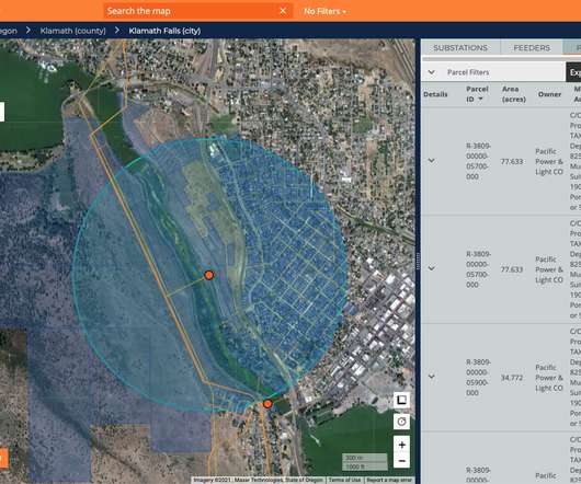
Map illustrates damage reports as hurricane hits North Carolina. 5, 2015— VisionLink , a community inspired software and consulting company, has developed a free, shareable, real-time, geo-tagged map depicting actual damage reports produced by Hurricane Joaquin. BOULDER, Colo. —
Big Sunday , a service organization based in Los Angeles, provided a list of resources during the wildfires in 2025, including evacuation sites, air quality maps, and insurance tips. Highlight the positives : When a disaster poses a threat, its easy to focus on the frightening images and statistics on social media and local news.
Earlier this year, the Network for Nonprofit Technology Solution Providers (NNTSP) organized as part of TechSoup Global, combining their resources to create a national network of local technology capacity-builders serving the nonprofit sector. Several of the NNTSP partners are combining efforts for a response to Hurricane Sandy.
Many do not have specialized skills but do have a passion to help those left hungry or stranded by a flood, hurricane, or fire. Prep a “Go Kit” As volunteers arrive for their assignments, provide them with necessary supplies, such as volunteer ID, maps, special equipment, and contact information for volunteer coordinators.
Relief organizations and first-responders are working tirelessly to provide aid to those affected by Hurricane Sandy. The staff at TechSoup Global is keeping all those affected by the devastating hurricane in our thoughts as we work to support recovery efforts. Google's Hurricane Sandy map currently shows areas with power outages.
She did a lot of work on the hurricane aftermath (she's an expert on hazardous waste, and a gazillion other things). The two places I looked for mechanisms are the (1) United Nations APELL program (Awareness and Preparedness for Emergencies on a Local Level) and (2) the U.S. I thought her comments would be worth posting.
(Android, iOS, Windows Phone) connects you with friends and family during a large-scale disaster such as an earthquake or a hurricane. The Esri ArcGIS app (Windows 8) is useful for organizations that wish to build their own relief-related maps. The app lets you preview different data skews and features from Esri's mapping software.
The benefits vary a discount to your local art museum, a branded T-shirt, a gift card. Say you operate a local food bank, and a tornado strikes your town. For instance, if youre on the ground feeding those affected by a hurricane, snap a few pictures of your setup and send them along with a thank-you message to your donors.
It means that there is a lot of local competition that you need to be aware of at all times when you are picking out your event dates. You don’t want to end up competing with another local event on the same exact evening. And don’t forget about hurricane season! Stay Away From Big Sporting Events. People love their football!
We need to utilize these tools, to the best of our abilities, to engage and inform the public, because no matter how much federal, state and local officials do, we will only be successful if the public is brought in as part of the team." As Robert Scoble pointed out, "It's not so much about technology but people."
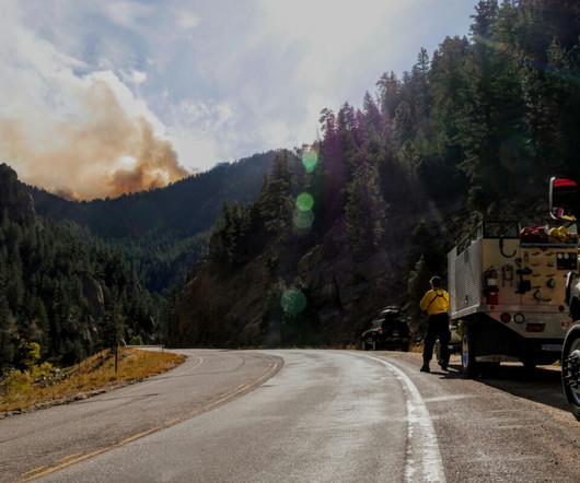
Hurricane Debby left downtowns from Savannah, Georgia to Annapolis, Maryland under water as it came ashore and stayed like an unwanted relative who won’t leave your home after a couple of days stretched into a couple of weeks. Severe weather season is underway and forecasts indicate a more intense hurricane season this year.
We invite you to dive into key findings from the report and explore granular data on our funding map. . Putting this best practice into action, in 2019—two years after Hurricane Maria hit Puerto Rico—the Amgen Foundation awarded $257,500 to the University of Puerto Rico for rebuilding efforts. . and internationally.
Twestival Local Weekend : Last February, Twestival raised over $250,000 for charity:water on Twitter on February 13th with more 200 cities sponsoring local tweet, meet, and give parties. September is Preparedness Month: We know that September is usually a bad month for hurricanes and other natural disasters. Inspiration.
Image Credits: Zeitview Since its founding, Zeitview claims it’s deployed drones to snap photos of wind turbines in the Atlantic Ocean, real estate complexes after a Texas hurricane and thermal data from “utility-scale” solar farms. billion in 2022.
There’s also more extreme weather conditions, with the latest power outages in New Orleans due to Hurricane Ida being a prime example of ways the current grid system falls short. The company’s data set, which Kevala founder and CEO Aram Shumavon says is in the terabytes range, is largely sourced from publicly available data.
Early in my career, I worked on the Race for the Cure in Houston when a hurricane swept through 10 days before our event. Our mission to end cancer is equally important as the hurricane relief efforts. Our mission to end cancer is equally important as the hurricane relief efforts. Looking for an alternative to a cycling event?
Another direct content example is that of the number of websites that emerged post-Hurricane Katrina. Some include the Red Cross, The Weather Channel, local newspapers, Craigslist, and others. The platform would then take their data, map it from their sending location, and create the other visual support data you see on the map.
When a hurricane or tornado starts to form, your local weather forecasters can quickly pull up maps tracking its movement and showing where its headed. In fact, a large number of private companies use NOAA data to create fancy maps and other weather products that they sell.
Pope John Paul II died, and Hurricane Katrina devastated New Orleans. An example of an API is when you put a Bing or Google Map on your website.). Google Maps. They eventually became hugely successful NetSquared Locals in several countries. " The year was 2005. TechSoup was then called CompuMentor. Podcasting.
I just read the news for today at my local newspaper’s online addition. When afterwilma debuted, I like many others felt an affinity to the people afflicted by the hurricane. We did start a group hurricane blog after Wilma, thankfully we have not put it to good use. I just don’t want to read that anymore.
But it’ll also fall on state and local governments. So what that is going to mean is that if you fast-forward 10 or 15 years, there are going to be regions of the country where you cant get a mortgage,” Powell told Congress. You’re seeing states step in because they want those areas to remain prosperous.
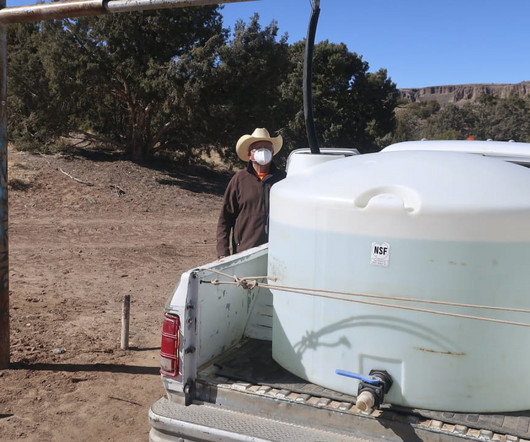
Malynndra Tome was helping to map livestock ponds in the Navajo Nation when she saw something that inspired her to act. In September, more than 100,000 residents in western North Carolina were under boil-water notices for nearly two months after Hurricane Helene destroyed much of a local water system.
We organize all of the trending information in your field so you don't have to. Join 12,000+ users and stay up to date on the latest articles your peers are reading.
You know about us, now we want to get to know you!
Let's personalize your content
Let's get even more personalized
We recognize your account from another site in our network, please click 'Send Email' below to continue with verifying your account and setting a password.


Let's personalize your content